The importance of water for our communities cannot be overstated, and it is more critical than ever to assess water resources accurately. A bathymetric survey is a valuable niche service that provides clients with the accurate data they need while offering greater efficiency and cost-effectiveness than traditional assessment methods. Galloway recently invested in and is excited to be offering bathymetric surveying to help support the decision-making process for their clients.
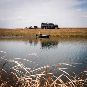 Traditionally, information on a body of water is collected from LIDAR, FEMA, other government agencies, and local municipalities. This information can be sufficient for preliminary submittals but may not be adequate for specific projects. Bathymetric surveys offer an alternative way to collect better data on bodies of water with increased efficiency and reduced cost.
Chris Pauley, PE, CFM, water resources team manager, stresses the importance of a bathymetric survey versus LIDAR data. “It is definitive data. You are taking a lot of the guesswork out of the workarounds, and we can make the data as precise or as detailed as a client wants,” he said.
This was evident in the Connell Resources project involving two recharge ponds in a mining operation in Fort Collins, Colorado.
“The client needed to have very accurate data calculations, and the LIDAR did not give them that,” said senior survey project manager, Reade Roselles, PLS. “That drove them to have us do a bathymetric survey.”
Instead of the client hiring a third party and utilizing rental equipment, Galloway efficiently completed an in-house bathymetric survey as part of their services. Additionally, by owning their equipment, Galloway does not face the scheduling roadblocks that other survey companies may face when they lease the equipment or rely on older technology.
Bathymetric surveying provides volume calculations and contours of the bottom of the water, identifies scours or other problems, and can be used to compare the current conditions of the body of water to the original design. Galloway’s water resources team can then utilize this data for projects involving water rights, hydraulic modeling, dam or structural safety analysis, and irrigation or reservoir maintenance.
“You may have a water right to store 400-acre feet of water, but over a hundred years, you may only have 300-acre feet of water as reservoirs will silt in,” said Pauley. “Without that storage, much revenue is lost, but getting rid of silt is not cheap. It is a balancing act, and the client must first know how much slime is at the bottom of the reservoir.”
Additionally, data breach analyses can be conducted to identify areas of weakness along a dam or underwater problems that could undermine a bridge pier or impact the adjoining landowners. Sometimes final submittals with certain government agencies also require highly detailed information.
“When you get into the final submittals with agencies like FEMA, they need much more accurate data that will meet the criteria for what they are analyzing. Bathymetric surveying provides that,” said Roselles.
We are nationally recognized and locally preferred. We would love to work with you on your next project.
Contact Us