When a project involves an existing building, one of the first questions architects and engineers must answer is: What is actually there?
Ditching the Guesswork for Measured Data
Existing drawings may be incomplete, as-builts (final construction documents) can be decades old, and renovations frequently go unrecorded. Uncovering the whole story through traditional field work means photographing, sketching and hand-measuring, which can take multiple days and pull in several disciplines.
Interior scanning, on the other hand, turns existing buildings into measurable project data in a fraction of the time manual surveys demand.
By combining LiDAR (Light Detection and Ranging) with SLAM (Simultaneous Localization and Mapping), a mobile scanner can map its surroundings while simultaneously tracking its position as it moves. Along the way, the scanner collects millions, sometimes billions, of measurements that are processed into a detailed 3D point cloud. Think of it as a digital replica of the environment, allowing surveyors, engineers, and designers to explore, measure, and analyze existing conditions from their desks rather than making repeated trips to the field.
At Galloway, the point cloud is often just the starting point. Our teams transform this data into practical, project-specific deliverables through scan-to-BIM, scan-to-CAD, and other modeling workflows. The result is an accurate digital representation of existing conditions that architects, engineers, and designers can use to make informed decisions, streamline design, and reduce uncertainty throughout a project’s lifecycle.
A Galloway survey team member uses a backpack SLAM scanner to capture existing conditions inside an industrial building for a manufacturing client in Utah.
How Design Teams and Projects Benefit
The Galloway Difference: Surveying, architecture, engineering and interior design teams work side by side. Scan data moves straight from field to designers, with no outside consultant. Teams can also revisit the data to verify measurements or probe details beyond the original scope.
“A lot of companies use scanning for one specific purpose,” says James Kessner, survey team manager at Galloway. “We’re looking at how we can use interior scanning and scanning in general across disciplines, from surveying to architecture and engineering. Having multiple disciplines in-house allows us to find new ways to apply the technology and deliver better results for our clients.”
One example is an office-to-residential conversion project where Galloway proposed interior scanning to document existing piping, ductwork, and equipment. The scans would help the team identify which systems can remain and which need to be removed, giving contractors a more clearly defined scope of work and a stronger basis for estimating demolition costs.
Choosing the Right Tools for the Job
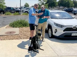
Galloway’s geospatial team using the Tersus MVP S2 SLAM scanner to capture detailed 3D data more efficiently in complex environments.
Each method has limitations, from reflective surfaces that can affect scan data to areas that are difficult to capture because of obstructions. Selecting the right technology and planning the capture process around those conditions helps ensure the resulting data meets the project’s needs.
“Clients tell us what they need, and we figure out the best way to capture and deliver the data within budget and on schedule,” says James.
Sometimes that means combining several technologies to capture conditions that a single method might miss. At Lost Valley Ranch, Galloway used aerial LiDAR to capture the broader property, terrestrial laser scanning to document cabin interiors, and SLAM technology to collect data beneath the tree canopy, where aerial scanning alone could not provide the same level of detail, specifically regarding the trunk sizes of the trees.
By selecting the right capture methods and connecting scan data with its in-house surveying, architecture and engineering teams, Galloway helps clients turn existing conditions into actionable project information. The result is a clearer understanding of what’s already there, helping teams make more informed decisions as they plan renovations, evaluate building systems and develop designs.
Learn more about Galloway’s surveying capabilities.
We are nationally recognized and locally preferred. We would love to work with you on your next project.
Contact Us