High-quality geospatial data informs smarter decisions at every stage of a project and, when applied strategically, this data reduces costs by minimizing rework, avoiding delays, and streamlining design.
To understand the full value of these services, it helps to clarify what geospatial surveying entails. Simply put, it’s the precise capture of spatial data about the Earth’s surface using tools like global navigation satellite systems (GNSS), light detection and ranging (LiDAR), photogrammetry, and total station instrumentation to create accurate 2D and 3D models for engineering and design.
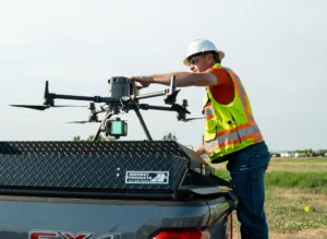
A Galloway survey team member prepares to fly a drone to collect data on a 600 acre site.
Unlike traditional land surveying, which focuses on exact measurements for property boundaries and site-specific needs, geospatial surveying covers a broader scope. It captures both natural and built environments, supporting large-scale planning, infrastructure, and environmental analysis. In other words, land surveying tells you where something is and geospatial surveying reveals what is there and how it all connects.
The strategic use of geospatial data has real, measurable impact on project outcomes. For example, on a recent Galloway project, our aerial LiDAR data revealed that legacy topography data had significantly underestimated slope gradients across the site. Our updated surface model prevented a costly redesign of the drainage plan and allowed the engineering team to realign infrastructure more efficiently. Without our data, those changes would have occurred at significant cost mid-construction.
Geospatial surveying also provides data that streamlines permitting by delivering accurate, high-resolution site information early, reducing guesswork and minimizing field visits. It also enhances safety by limiting crew exposure to hazardous environments such as active construction sites, steep or unstable terrain, roadway corridors, water-adjacent areas, sub-stations, railways and rail rights of ways, and industrial facilities. Tools such as aerial LiDAR and drone mapping allow us to capture data remotely, resulting in faster turnaround, fewer field hours, and fewer safety risks.
To maximize these benefits, it’s critical to involve the geospatial team as early as possible, ideally during site selection or feasibility. Early access to high-quality data empowers smarter design decisions, supports regulatory compliance and helps avoid costly revisions down the line. Waiting too long to integrate geospatial insights can result in scope gaps and unverified assumptions that may increase project time and costs.
Galloway’s geospatial survey team brings decades of combined experience in land surveying and remote sensing. We’ve successfully delivered high-accuracy mapping on a wide range of projects from urban infill developments to remote transmission corridors using advanced tools tailored to each project’s needs.
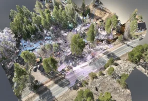
Aerial lidar and photography combined with terrestrial lidar of a project site in Northern Colorado.
What truly distinguishes Galloway’s geospatial surveying isn’t just the technologies we use, but how we apply them. Our focus on integrating new technology is not to cut corners or replace trusted methods, but to enhance our capabilities and maintain the highest standards.
Equally important are the people behind the technologies. We invest in passionate team members who lead innovation, balancing advanced tools like drone-based LiDAR with proven techniques such as GPS validation. This careful, dual-method approach builds confidence in accuracy and reliability.
In combining experience, collaboration, and a strategic mindset, we tackle complex projects efficiently by delivering precise, dependable results without sacrificing quality or cutting corners.
This collaborative, precision-focused approach is a key part of how geospatial surveying fits within Galloway’s Full Spectrum Approach™. We work closely with engineers and architects to ensure our data aligns with their design needs, optimizing data early to prevent errors and delays throughout the project.
Visit our Land Survey page to learn more about Galloway’s surveying capabilities.
We are nationally recognized and locally preferred. We would love to work with you on your next project.
Contact Us